Land Nav Assistant
- 4.1
- Rating
- 50.00K
- Installs
- $2.99
- Price
 Analysis by App-foxy
I approached Land Nav Assistant as a practical navigation tool rather than another general map app. Its focus is clear: it is built around GPS positioning in MGRS and latitude/longitude formats, with military and outdoor use in mind. That makes it more specialized than the navigation apps most people keep on their phones, but that specialization is also its main reason to exist.
In my experience, the app makes the most sense when you already understand why coordinate formats matter. If you are hiking, practicing land navigation, working with a paper map, or checking a position in a format used by someone else, it can be much more direct than trying to force a conventional road-navigation app to do the same job. If all you need is turn-by-turn driving directions, I would choose a different kind of tool.
How I used it for a dependable navigation routine
The most useful way to begin is to treat the app as a coordinate instrument. I first give it time to establish a sensible GPS position, then check which coordinate format I need before moving on. That small pause matters because MGRS and latitude/longitude are not interchangeable in the way a casual map pin might suggest. A good workflow starts with the destination or reference format, not with randomly tapping through screens.
You May Also Like

 Blood Strike: 2.5 Anniversary
Blood Strike’s Loadouts Turn Every Drop Into a Tactical Gamble
A close look at Blood Strike’s custom loadouts: how fast access to signature weapons reshapes its battle royale rhythm, rewards preparation, and narrows the gap between fights.

 Pandora - Music & Podcasts
Pandora’s Music Is Easy to Start, but Harder to Recover
Pandora’s strength is its low-effort path from a seed to a station. Its weak spot is how much confidence it asks you to place in connection, setup, and quiet recovery.

 8 Ball Pool
 Is Built on Rivalries, Rematches, and Routine
A close look at the rivalries, rematches, shared routines, and unanswered safety questions that turn a quick pool match into a persistent mobile community.

 Samsung Music
’s Quiet Strength Is Playing What You Already Own
Its reach comes less from spectacle than from dependable access to a personal library. That simplicity is both the app’s strongest retention engine and its ceiling.

 AccuWeather: Weather Radar
AccuWeather Review: A Quick, Clear Forecast for Everyday Decisions
For everyday plans, the best forecast is the one you can understand quickly. AccuWeather makes rain timing, radar, and local conditions easy to act on, with a few trade-offs.

 Hill Climb Racing
Why Hill Climb Racing Still Turns Crashes Into One More Run
A tiny car, a bumpy hill and one more upgrade: Hill Climb Racing keeps resurfacing because its simple chaos makes every near-miss feel personal.
More From Our News Desk



For a simple outdoor exercise, I would keep a paper map or another trusted reference beside the phone, open the app, and compare the displayed position with the location I expect. This is a better first test than immediately relying on it in an unfamiliar area. It lets me find out whether I am reading the coordinate correctly, whether the phone has a dependable view of the sky, and whether my own map-reading habits are sound.
The app’s appeal is that it puts MGRS navigation and latitude/longitude navigation in the same focused environment. That is especially useful when a group does not use one universal format. One person may give a grid reference while another shares decimal coordinates. Instead of converting everything mentally or switching between unrelated tools, I can use the format that matches the task and keep the interpretation closer to the source.
A realistic everyday scenario would be a weekend hike where a friend sends a coordinate in latitude and longitude, while my printed topographic map is marked for MGRS. I would use the phone to inspect the incoming position, confirm the area on the map, and then use the grid reference as the working language for the route. The important habit is not simply reading the screen; it is cross-checking the coordinate against terrain, map detail, and the direction I am actually traveling.
That cross-check is one of the app’s biggest practical lessons. A phone can show a precise-looking position while the user is still interpreting the wrong datum, grid zone, or coordinate order. I would never treat a coordinate display as a substitute for navigation knowledge. Instead, I use it as one part of a repeatable process: identify the format, verify the reference, compare it with the map, and only then act on it.
What the basic screen is good at
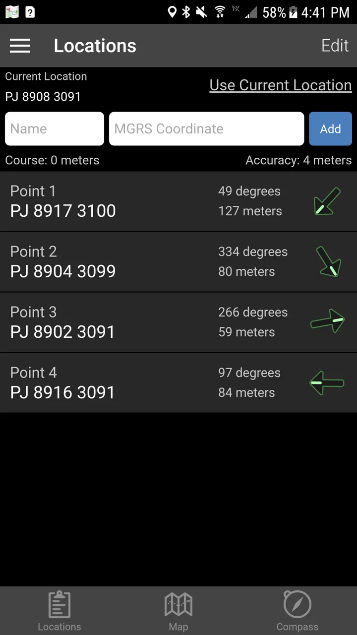
Land Nav Assistant is strongest when I need a current position or a coordinate-oriented reference without the visual clutter of a full consumer map service. The developer, Land Nav Assistant, has kept the concept narrow enough that the app feels aimed at people who know what they want from a navigation display. That focus is valuable during training or outdoor planning, where a large collection of unrelated map features can become a distraction.
I also like the idea of keeping the app open during a short pause rather than constantly checking it while walking. I can stop in a safe place, read the position, compare it with my route notes, and continue. This reduces the temptation to stare at a screen while moving and makes the phone a deliberate reference tool instead of a permanent source of reassurance.
There is a trade-off, though. A specialized coordinate app does not automatically provide the same comfort as a mainstream mapping application. People who expect obvious place labels, polished route planning, traffic information, or familiar visual guidance may find the experience too bare. That is not necessarily a defect in this app’s intended role, but it does mean I would pair it with a map or navigation solution when the trip requires broader context.
Settings I would check before leaving
Before using the app outside, I would review every coordinate-related option that is visible and make sure it matches my reference material. The most important setting is the coordinate representation itself. If my map, instructor, or group uses MGRS, I would not leave the phone in a latitude/longitude view simply because it was the last format I used. A mismatch at this stage can create confusion later, even when the phone is working normally.
I would also check the phone’s location behavior before depending on the app. GPS performance is affected by the device, surroundings, and visibility of the sky, so I would test it near the actual starting conditions rather than assuming an indoor reading represents outdoor performance. In a wooded area, canyon, or built-up location, I would allow extra time and avoid treating the first displayed position as final.
Another useful habit is to set up the app before the activity begins. I would choose the coordinate style, confirm the screen is readable, and make sure the phone is charged before reaching the trailhead or training area. These are ordinary preparations, but they are more important with a focused utility because there may be less visual guidance to rescue a rushed user.
The app is suitable for Everyone from an age-rating perspective, but that should not be confused with being effortless for everyone. A young or inexperienced user can open it, yet understanding MGRS, map scales, and coordinate references still takes practice. I would introduce it alongside basic navigation instruction rather than handing it to a beginner and expecting the display alone to explain the landscape.
One setting-related trade-off I pay attention to is precision. More digits can suggest more certainty than the phone’s actual position supports. When I record or communicate a coordinate, I would use a level of detail appropriate to the situation and the quality of the GPS fix, rather than copying every available character automatically. The app can present a coordinate, but the user must decide how much precision is meaningful.
Shortcuts and repeatable patterns that save time
Experienced use is less about discovering a secret button and more about reducing decisions. I would keep one standard routine for moving from a shared coordinate to a verified location. First identify whether the incoming reference is MGRS or latitude/longitude. Then enter or inspect it in the matching form, compare the result with the map, and only afterward use the position for movement. Repeating those steps prevents the common mistake of mixing formats halfway through.
For field work, I would also keep a small written note of the coordinate convention being used that day. This is particularly helpful when switching between a training exercise and a recreational hike. The note acts as a reminder when the phone is passed between people, and it avoids making the app responsible for remembering the context of every coordinate.
A second efficient pattern is to use the app at decision points rather than continuously. I might check at the trail junction, at a planned rest stop, or after crossing a feature that is easy to identify on the map. This preserves battery and attention while still giving me regular confirmation. It also encourages navigation by terrain and map features instead of following a screen without thinking.
I find this approach more useful than trying to imitate a car-navigation experience. On roads, constant instructions are often the point. In outdoor navigation, the better question may be whether the current position agrees with the route plan and the surrounding terrain. Land Nav Assistant fits that reflective style better than a voice-guided route service does.
When working with another person, I would agree on one communication format before starting. If one person reads MGRS and another expects latitude/longitude, even a correct position can become a communication problem. The app is helpful because it centers both systems, but it cannot remove the need for a shared convention. I would say the format aloud, repeat the key part of the coordinate, and compare it with the map rather than relying on a hurried message.
There is also a useful paper-and-phone combination. I would mark the planned area on a printed map, use the app to check my current position, and write down important references instead of assuming the phone will always be available. That workflow gives the app a clear job and leaves the map responsible for terrain, distance, and route interpretation. It is more resilient than asking a coordinate display to provide the entire navigation picture.
Where the focused design reaches its limits
The main limitation is not that the app is too specialized; it is that specialization narrows the audience. Someone searching for restaurant discovery, public-transit directions, live traffic, or ordinary street navigation should skip it. Those tasks are better served by mainstream mapping apps designed around places, routes, and visual context. Installing this tool will not turn it into a replacement for those services.
I would also be cautious about using it as the only safety resource in remote country. A phone GPS reading is useful, but reception, battery, weather, terrain, and device reliability still matter. A paper map, compass, spare power, and knowledge of the area remain sensible companions. The app can support a navigation plan; it should not be the plan’s only foundation.
Another limitation is the learning curve around MGRS. Users familiar only with street addresses may initially see a string of letters and numbers without an obvious mental picture. The app can make the format available, but practice is needed to understand grid zones, map references, and the difference between reading a position and navigating to it. I would spend time learning those basics in a familiar place before attempting a demanding route.
There is a similar issue with accuracy expectations. A coordinate can look exact while the actual position fluctuates. Buildings, trees, slopes, and atmospheric conditions can affect the phone’s location estimate. I would use the displayed position as evidence, not absolute truth, and look for agreement over time or with visible landmarks. That is a crucial distinction for anyone moving from casual phone maps to field navigation.
The paid price is $2.99, which I see as reasonable if I will genuinely use MGRS or coordinate-based navigation. It is harder to justify for someone who only wants occasional directions, especially when free general-purpose mapping tools already cover ordinary travel. The value depends on whether this focused workflow saves confusion during the activities I actually do.
The app has been available since Jan 23, 2012, and its current version is 2026081710. It supports Android 7.0 and later, which makes it accessible on a broad range of Android devices, though the real-world experience will still depend on the phone’s GPS hardware and screen. I would check compatibility before an important trip, then test the exact device I plan to carry rather than assuming every Android phone behaves alike.
How it compares with familiar alternatives
Compared with a typical consumer map app, Land Nav Assistant feels more like a coordinate reference than a complete travel planner. General map apps win for searching businesses, building road routes, viewing familiar streets, and giving casual users immediate visual orientation. This app wins when the coordinate system itself is central and I do not want that task buried under unrelated map features.
Compared with a dedicated handheld GPS, the phone-based approach is convenient because the device is already familiar and the app costs less than buying another navigation unit. A handheld can still be preferable for people who spend long periods outdoors, need purpose-built controls, or want a device reserved for navigation. I would choose between them based on the seriousness of the trip, not simply on which screen looks nicer.
Compared with a paper map and compass, the app is faster for checking a current coordinate, especially when someone gives me a reference digitally. Paper and compass remain stronger for broad terrain awareness, route planning, and backup use. My preferred setup is not either-or: I use the app to confirm position and the map to understand where that position matters.
Its rating is a 4.1 average from around 339 ratings, with roughly 113 written reviews, and it has passed 50K+ installs. Those figures suggest a real but specialized audience rather than a mass-market navigation product. I would read that as a sign to judge it by fit: the app does not need to appeal to every phone owner if it handles the coordinate workflow I need.
Who should use it and who should pass
I would recommend it to hikers who work with grid references, outdoor learners practicing map skills, military-oriented navigation users, and anyone who regularly receives locations in MGRS or latitude/longitude. It is also a sensible companion for instructors who want students to connect a live phone position with a paper-map exercise.
I would not recommend it as a first choice for a tourist looking for attractions, a driver planning a city journey, or a family wanting the simplest possible location sharing. Those users are likely to value search, routing, and visual landmarks more than coordinate formats. The app’s focused nature would add friction instead of removing it.
For beginners who are interested but inexperienced, I would recommend a gradual start. Use it in a park or familiar neighborhood, compare the displayed position with a map, and practice saying coordinates clearly. Once that feels natural, add it to a short hike with a backup plan. This approach teaches the workflow without making a new tool responsible for a high-consequence situation.
My verdict after building a practical habit around it
Land Nav Assistant is a focused Android navigation app that earns its place when MGRS or latitude/longitude is more important than turn-by-turn convenience. I like it because it encourages a disciplined relationship with coordinates: choose the right format, verify the position, compare it with the map, and use the result thoughtfully. That is more valuable to me than a crowded interface full of features I will not use.
Its weaknesses are equally clear. It is not the universal map app some readers may expect, and it cannot replace navigation knowledge, a paper backup, or sensible preparation. The price is modest, but only users with a genuine coordinate-based need will get consistent value from it. Everyone else may find a conventional map service easier and more useful.
My final recommendation is therefore conditional but positive: if your outdoor routine involves MGRS, coordinate sharing, or deliberate land-navigation practice, I would try it and build a repeatable workflow before relying on it. If your needs are ordinary road directions or place discovery, I would skip it. The app is at its best as a precise field reference, not as an all-purpose map replacement.
FAQs for Land Nav Assistant
01What is Land Nav Assistant used for?
Land Nav Assistant is designed to help users plan and navigate routes in outdoor environments using maps, coordinates, waypoints, and other land-navigation tools. It can be useful for hiking, camping, field training, hunting, or general orientation away from roads. The app is best viewed as a navigation aid rather than a replacement for map-reading skills, a compass, or proper preparation.
02Does Land Nav Assistant work without an internet connection?
Offline availability depends on the app version and the maps or data you prepare before leaving coverage. GPS positioning itself can often work without mobile data, but map imagery, searches, route downloads, and online services may require an internet connection. Before heading outdoors, users should open the required area, download or cache available map data if supported, and test the app in airplane mode.
03Is Land Nav Assistant accurate enough for hiking or field navigation?
The app can provide useful position, bearing, distance, and waypoint information, but accuracy depends on the phone’s GPS hardware, satellite reception, weather, terrain, tree cover, and the quality of the map data. Buildings, deep valleys, and dense forests may reduce accuracy. For safety-critical navigation, confirm the app’s readings with a physical compass, printed map, and established outdoor-navigation procedures.
04What features should I expect when using Land Nav Assistant?
Land Nav Assistant generally focuses on practical land-navigation functions such as viewing a map, recording or entering coordinates, creating waypoints, measuring distance and direction, and assisting with route planning. The exact tools may vary by platform and version, so users should review the current store listing before downloading. Some functions may also require location permissions, storage access, or additional map data.
05Is Land Nav Assistant suitable for beginners, and what permissions does it require?
Beginners can use Land Nav Assistant, but a short learning period is recommended because coordinate formats, bearings, map scales, and waypoint tools may be unfamiliar. The app normally needs location permission to show your position and may request storage, notification, or network access for maps and saved data. Grant only permissions that match the features you intend to use, and practice before relying on it outdoors.
Pros
- Works offline
- making it useful in remote areas without mobile coverage.
- Supports multiple map and coordinate formats for varied navigation needs.
- Waypoint tools help mark
- save
- and manage important locations.
- Can assist with route planning for hiking
- hunting
- and outdoor exploration.
- Useful navigation features are available without requiring a constant data connection.
Cons
- Its interface may feel dated compared with newer outdoor navigation apps.
- Some advanced mapping features may require additional downloads or setup.
- Accuracy depends on your device’s GPS signal and available map data.
- Coordinate formats can be confusing for beginners unfamiliar with land navigation.
- Battery use may increase during extended GPS tracking sessions.

Land Nav Assistant
Gallery